Sunday, May 31, 2015

Boyce Johnson Arboretum Florence AZ

Boyce Johnson Arboretum near Florence AZ was 
established by one of the copper barons and represents over 1500 varieties of desert plants from all over the world.


Blooming Yucca

Palo Verde tree.  Note the bark of the Palo Verde is green. 


Succulent in bloom. 

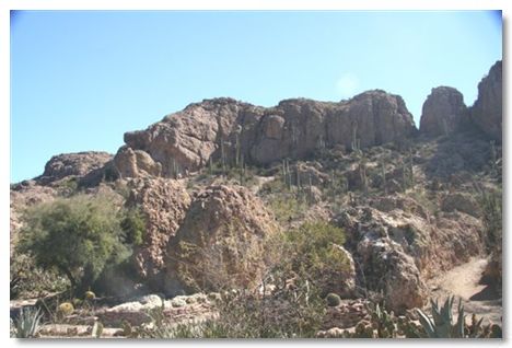
Several cactus varieties are in this picture. 


The property is part of the former mining area.  The ridge in the rear is a magma bridge formed by volcanism a long time ago. 

 
Boojum Tree.  The very tall, slender tree is found naturally only in Baja California and on the coast of Sonora.  This tree was planted here in 1927 and was 10-feet tall.  The trees grow about 4-inches per year. 


As we tarried at a shelter near a small body of water, we were visited by this small gecko.


Even in the desert, one can find beautiful flowers.  Although these in the Arboretum have benefit of frequent artificial watering. 

This garden is along the pathway through the Boyce Thompson Arboretum. 


Bowling Green OH 2006

Bowling Green OH

A stop for service to the diesel engine in nearby Maumee allowed us 
to visit old friends, the McCauslands in Waterville and to learn a 
bit of the area's history.


We stayed at Fire Lake Campground just south of Bowling Green OH so we could keep an appointment to have regular service done on the engine and chassis of the motor home at an authorized Cummins shop in Maumee, about 20 miles north.  High School classmates and  friends, Tom and Hazel McCausland, live in nearby Waterville, so we got a chance to visit them while there.  Here we all are at their home.

Tom is very interested in the local history and was eager to share his knowledge with us.  Roche de Boeuf Standing in the Maumee River is a massive limestone rock that has been a landmark and site of many historical events in the region.  Native tribes considered it a sacred place and gathered their forces there prior to the Battle of Fallen Timbers in August 1794 just a few miles away.  It takes its name from a French settlement of the 1700s that was nearby and from the shape of the outcrop which may resemble a bison if you look with one eye squinting!


The river is shallow in many places as it flows over bedrock.  Here a blue heron fishes watchfully for a meal.

William Henry Harrison built Fort Meigs on the Maumee River in 1813 to protect northwest Ohio and Indiana from British invasion. Today's reconstruction is one of the largest log forts in America. British and Canadian troops, assisted by Indians under Tecumseh, besieged the fort twice. The 10-acre log enclosure with 7 blockhouses and 5 emplacements presented a formidable defense. The first assault was in May of 1813 and the second was in July. Both failed and the British retreated after the second. In the spring of 2003, the fort underwent a major renovation and the construction of a Museum and Education Center.


Who knows what this tree is?  It has unusual large spikes growing from bud points along the trunk.  In the next photo is a closeup of the leaves.  If you know it, please let me know.


Closeup of the thorns and my hand.

Fort Miamis.  British soldiers constructed Fort Miamis in 1794. British authorities feared that Anthony Wayne and his army planned on marching against Fort Detroit, a major English stronghold. Located fifty-five miles to the south of Detroit, Fort Miamis provided an additional obstacle to Wayne. Fort Miamis also afforded the British additional means to solidify Native American support against the white Americans moving into the Ohio Territory. Following England\'s defeat during the American Revolution, the British promised in the Treaty of Paris (1783) to remove all of their soldiers from American soil. Although they agreed to do this in the treaty, the British subsequently refused until the Americans honored their pledges-namely repayment of debts Americans owed to England-in the treaty as well.


Fort Miamis, in present day Maumee, OH,  consisted of four bastions (diamond shape projections of the wall). The British dug a twenty-five foot deep trench around the fort and lined it with rows of stakes to impede an enemy\'s assault of the fort. The British also placed fourteen cannon in the fort to thwart any attackers.   The remains of the trenches can be seen in these two photos and are all that is left today of Fort  Miamis.

William Henry Harrison built Fort Meigs on the Maumee River in 1813 to protect northwest Ohio and Indiana from British invasion. Today's reconstruction is one of the largest log forts in America. British and Canadian troops, assisted by Indians under Tecumseh, besieged the fort twice. The 10-acre log enclosure with 7 blockhouses and 5 emplacements presented a formidable defense. The first assault was in May of 1813 and the second was in July. Both failed and the British retreated after the second. In the spring of 2003, the fort underwent a major renovation and the construction of a Museum and Education Center.


Cannons sit high over the Maumee River inside Fort Meigs. 


The museum at Fort Meigs records the Sixty Year War for Ohio, and building Fort Meigs. Original artifacts from the War of 1812, including swords, uniforms, and maps highlight the events of the war and the impact it had on soldiers and their families.
The Museum and Education Center has 3,000 square feet of exhibits and artifacts - including soldiers' letters and diaries, weapons, maps, and uniforms - that describe Fort Meigs role during the War of 1812.


This was our "front yard" at Fire Lake Campground near Bowling Green OH.


Sunset at Fire Lake Campground, Bowling Green OH.


Benson AZ 2006

Some  pictures of Historic Buildings in Benson, near where we stayed Nov 05 to Jan 06

The Double Roofed House is the largest example in Arizona of this building type.  
The second roof was added to provide insulation from the heat.  
Badly in need of stabilization, there is an effort underway to begin to protect this relic of the past.

Considered one of the grandest homes in Benson, this is known as the Roadmaster's House.  
The Roadmaster was responsible for maintenance and repair of the railroad 
tracks and right of way.  Such an important man required an important home.

The main street through town is State Route 80.  
This view shows a couple of the old business places in their present use.

This mural on one of the downtown buildings evokes memories of the
 past glory of stagecoach and rail transportation in Benson.

Benson AZ was founded in 1880 as a major transportation center. 
The southern pacific Railroad maintained a 6 stall railroad turntable here.  The town served the transportation
 needs for the mining industry 60 - 100 miles to the south in Bisbee and Tombstone.

Today Benson is a tourist center and winter stopover for retirees in motor homes.  
The former railroad passenger station has been restored and serves as the Visitor 
Information Center in town.  Southern Pacific tracks still pass through town and 
many trains pass daily.

This shuttered building is still owned by the descendants of Chinese immigrants 
who came to town during railroad construction.  The Wo Hi Company 
operated a general merchandise and grocery  store here from 1896 to 1989.

The Zearing Mercantile building is one of the town's earliest.  
On the National Register, it has been restored.

Tuesday, May 26, 2015

Bannack MT State Park

Bannack Montana was the site of the first gold discovery in 
Montana Territory in 1862 and it soon became a boom 
town.  Along with the riches, came an unsavory 
crowd that would make the town famous for other reasons.

This is a view along the main street in Bannack which in its prime 
was home to about 3000 miners and assorted others.

The one-room school occupies the first floor of this building and the Masonic Lodge is upstairs.

Originally this building, built in 1875 at a cost of $14,000 was the first County Courthouse 
of Beaverhead County.  By 1881 the gold deposits petered out and Montana\'s
 gold rush was history.  Livestock ranches and agriculture became the principle businesses 
in the county.  Nearby, the town of Dillon was growing because it was located at a 
railhead and was evolving into a flourishing freighting center.  In 1881 the county seat was 
moved from Bannack to Dillon.This building stood empty until about 1890 when it was converted into the Hotel Meade, so named for its new owner, Dr. John Singleton Meade. 
It soon became the center of Bannack social activity and served as host to many Montana travelers.  It remained in service until the 1940s.

The curved staircase from the lobby of the Hotel Meade to the second floor guest rooms 
gives a small sense of the elegant features once prominent inside.

The bar at Skinner's Saloon.  Henry Plummer arrived in Bannack in late 1862 
after having spent time in San Quentin Prison.  He apparently was a likeable sort 
and soon convinced the miners court to elect him as sheriff of the bustling gold 
town.  Plummer immediately organized a group of about 25 of his followers into 
a group which they called the "Innocents"; also known as “Road Agents”.   
In the unlikely event any were ever arrested, they would proclaim their innocence.  
This group is estimated to have robbed and murdered more than 100 people 
in only eight months they terrorized the gold camps.

In the 1940s, Bannack was pretty much deserted and in a state of 
decay when a group of locals from Bannack and Dillon began efforts to preserve 
the town.  By 1954 the town, which had been acquired by the Beaverhead 
County Museum Association, was donated to the State of Montana with the 
stipulation that it was not to be made into a tourist town, 
but should retain its ghost town atmosphere.

The Methodist church was built in 1877 and was the first building 
in town exclusively for the purpose of worship.  
Surely there was plenty of soul saving to be done with all the 
gambling, bars, prostitution and general mayhem going on.

Remains of a necessary facility behind the church.

There's still gold in the hills around Bannack, although the land is State owned and no mining is permitted.

A typical house in Bannack with a small barn in back and the hills beyond.

I just thought this was a pretty picture!

The jail was built by Sheriff Henry Plummer and from its windows, 
inmates could view the gallows just up the hill from here.  
Not such a subtle reminder of the fate of criminals.  Plummer 
himself would eventually suffer consequences of his activities 
with the Road Agents at the same gallows!

A view inside the masonic Lodge.  It is the only building with any artifacts remaining.


Ashtabula OH 2005

Covered Bridges we saw in Ashtabula 
     County OH June 2005

Benetka Road Covered Bridge combines the arch with town lattice for support.  
It crosses the Ashtabula River in Sheffield Twp and was built sometime in the 1890s.  
It is still in service.

Benetka Road Covered Bridge combines the arch with town lattice for support.  
It crosses the Ashtabula River in Sheffield Twp and was built sometime in the 1890s.  It is still in service.

So-called Pratt Trusses support the Caine Road bridge.

Caine Road covered bridge is of the Pratt Truss type construction.  It crosses the West Branch of the 
Ashtabula River in Pierpont Twp.  It is 96 feet long and was built in 1896 by the Ash Company

This is State Road Covered Bridge.  It is a modern structure having been built
in 1983 to cross Conneaut Creek in Monroe Twp.  It is 157 feet in length.

The Doyle Road bridge uses a combination of 
Burr Arch and Town Lattice for support.

Doyle Road Covered Bridge crosses Mill Creek in Jefferson Twp.  
It was constructed in 1868 and is 94 feet long.  It is still in use.

Pratt Trusses in Giddings Road bridge.  Unlike the bridges we saw in Indiana which were mostly built 
by the same builder, these of Ohio were the work of several builders ans show differences in style 
and technique.  Each seems a little different than another and makes them more interesting.

Giddings Road Covered Bridge

I think this is the only red painted bridge we saw here.  
Note the cute little cupola on top.  It is on Netcher Road.

This bridge on Root Road was built in 1868 and has been restored in 1982-3.  It carries traffic yet today across the Ashtabula River in Monroe Twp 
spanning a length of 82 feet with an overall length of 112 feet.

This cross hatch style for support structure is called "town lattice" 
and is used on several of the bridges we saw. Here on South Denmark Bridge.

South Denmark Bridge was built about 1895 to cross Mill Creek in Denmark Twp.  
It spans 76 feet and is overall 100 feet long.   The bridge is no longer in general service.